
Cycle Instead Help Page

TIPS FOR USING THE CYCLE INSTEAD JOURNEY PLANNER
1. My Route Type Options
Route Type:
Three route type options are available for you to try:
| Fastest | The Cycle Instead Journey Planner will suggest a route that is likely to be fastest by bike. This is the default option and considers all available roads and paths, including main roads, local roads and off road paths. |
| Low traffic | The Cycle Instead Journey Planner will suggest a route that is mostly comprised of Bikedirect secondary roads and off road paths and is as direct as reasonably possible. Secondary roads generally have light to medium traffic and run parallel to and connect with main roads. |
| Maximise Paths | This option will suggest a route that uses paths, instead of roads, where possible. Please be aware that by selecting this option, the suggested route may be considerably longer than the fastest route in order to meet this preference. |
Gradients
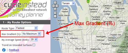
Max Gradient (%):
- You can customise your route to avoid hills by selecting a preference in the Max Gradient drop down box. The default setting is No Maximum, which allows the Journey Planner to consider all possible routes, regardless of hills. If you select a value for the maximum gradient you are willing to ride, then the Journey Planner may suggest a longer route to accommodate this request.
- In some hilly areas, a route with a particular maximum gradient may simply not be possible. Try again with a higher maximum gradient value.
- The journey planner may not detect short hills (e.g., hills shorter than 50m) or structures (e.g., bridges, underpasses).
My Average Speed:
You can change your approximate average speed from the default setting of 20km/h. The Cycle Instead Journey Planner uses this input to estimate how long your suggested route will take. 20km/h is a moderate pace for a reasonably fit adult, so if that is not you, adjust accordingly.
Travel on Unsealed Surfaces:
An unsealed surface includes paths that may be dirt, dolomite or gravel. Tick this box if you would like the Cycle Instead Journey Planner to consider these types of paths when generating your route. Please note that these routes may be unsuitable for some types of bicycles and can be more affected by wet weather than other surfaces.
2. Find My Locations
You can add up to five locations in your journey plan. Add locations in the same order which you would like to arrive.
| Example: if you would like to travel from Largs Bay to Adelaide via Torrensville, click on Largs Bay first, Torrensville second and Adelaide third). |
Locations can be added by one of two ways:
- Type in: an address or location in the Address box. The Cycle Instead Journey Planner will confirm the address for you as you type. Click on the address below that best matches your location and it will be added to My Locations. If your address cannot be confirmed, try entering an address nearby your intended location or check the spelling.
- Click on: the map. You can either use the arrows in the top left hand corner of the map window, or click and hold down the button on your mouse and drag the cursor to your location, in order to move the map around your screen. Use ‘+’ or ‘-’ map buttons or mouse scroll wheel to zoom in and out as desired. Click on your location once found and this will be added to My Locations. Repeat these steps to add extra locations.
If you make a mistake entering your locations, or if locations were added in the wrong sequence, click the Reset Map button at the bottom left to start again.
When you have added in all your locations, click Suggest Route. The Cycle Instead Journey Planner will display a route based upon the options you had selected. You can change any of the ‘My Route Options’ and click Suggest Route again, without having to reset the map. Your route will be recalculated and displayed. Try different options to consider alternative routes.
The Cycle Instead Journey Planner currently only covers the greater Adelaide urban area, from Gawler to Willunga. Some Adelaide Hills locations are also not included. If you select a location outside of the map extent, you will get an error message.
Map Features
On the top right hand side there are show/hide functions for legend and results.
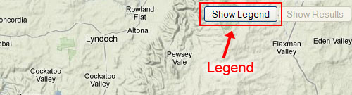
Show/Hide Legend – When using the Cycle Instead Journey Planner you can add additional information to the map using the Show Legend button. Additional information includes the Bikedirect network showing you bicycle lanes and paths, bicycle lockers at public transport stops and stations, traffic signals and other useful information. Click on Hide Legend to hide the window.
Show/Hide Results - your route results will appear in a box on the map screen, detailing your suggested route distance and approximate travel time. You can hide this box by clicking Hide Results on the top right of the map screen. The Route Results box also allows you to view, in pop- up windows, your route directions (turn by turn) and a printable map.
Map Type - Select the map you would like to use from the dropdown box, next to the navigation arrows.

This feature provides you with options to choose the format in which your map is presented. You can select from the following:
| Terrain (default) | shows the map while identifying hills and greenspaces |
| Map | road map view |
| Satellite | a ‘birds eye’ view of your route, including houses, buildings and foliage |
| Hybrid | a mixture of map and satellite view |