Northern Adelaide Suburbs Road Upgrades
As part of the State Government’s election commitments, we upgraded and investigated potential upgrades in the northern suburbs to improve safety, access and to make travel easier for all users.
Completed projects
-
John Rice Avenue and Haydown Road Junction UpgradeImproving safety for all road users and supporting growth in the Lyell McEwin health precinct.
-
Main North Road and Target Hill Road Junction UpgradeCreating safer right turn movements for vehicles exiting Target Hill Road onto Main North Road in Salisbury Heights.
-
The Grove Way and Canterbury Drive Junction UpgradeReducing congestion and improving access for vehicles exiting Canterbury Drive onto The Grove Way in Salisbury Heights.
-
The Grove Way and Green Valley Drive Junction UpgradeIncreasing safety for vehicles exiting from Green Valley Drive onto The Grove Way in Salisbury Heights.
-
The Grove Way Intersection Upgrades, Golden GroveImprovements on high-risk roads or roads with proven crash history.
-
Wynn Vale Drive and Bridge Road Junction UpgradeImproving safety at the junction of Wynn Vale Drive and Bridge Road in Gulfview Heights.
-
Yorktown Road and Adams Road RoundaboutInstallation of a single lane roundabout at the junction of Yorktown Road and Adams Road in Elizabeth Downs.
Locations of projects in northern Adelaide
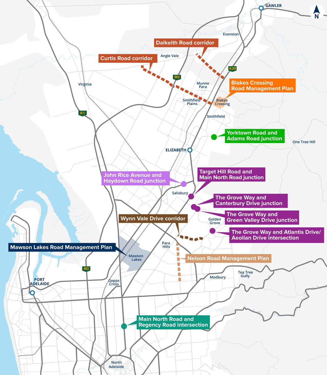
Map of all project locations for upgrades, or potential upgrades under this program.
Further locations under the Northern Adelaide Suburbs Road Upgrades program
Mawson Lakes Road Management Plan
With input from the City of Salisbury, we have prepared a Road Management Plan (RMP) for the Mawson Lakes local area.
In early 2023 we undertook community and stakeholder consultation, where we collected valuable insights that contributed to the preparation of the RMP. Thank you to everyone that gave feedback and contributed to the consultation. The summary of the feedback received is incorporated in the RMP.
The RMP was developed to analyse existing local accessibility concerns within Mawson Lakes and to explore potential improvement opportunities that can enhance active travel including public transport use.
View the Mawson Lakes Road Management Plan (PDF, 1.5 MB).
Nelson Road Management Plan
With input from the City of Salisbury, we have prepared a Road Management Plan (RMP) for Nelson Road, from Wright Road to McIntyre Road.
In late 2022 we undertook community and stakeholder consultation, where we collected valuable insights that contributed to the preparation of the RMP. We would like to thank everyone that provided feedback and contributed to the consultation. The summary of the feedback received is incorporated in the RMP.
The RMP was developed to analyse existing issues and explore potential improvement opportunities to reduce traffic congestion and enhance road safety for all road users.
Blakes Crossing - Traffic Management Plan
We have partnered with the City of Playford to deliver a traffic management plan at Blake’s Crossing. The study will investigate local traffic issues such as speeding, parking, pedestrian safety around schools and shopping areas and traffic and road safety.
City of Playford sought feedback from the community to understand local residents traffic experiences. This survey is now closed.
For more information visit playford.engagementhub.com.au.
Main North Road and Regency Road intersection - Planning Study
A traffic management plan is being developed for the Main North Road and Regency Road intersection to investigate potential options to improve traffic flow, reduce waiting times for motorists and improve pedestrian safety and access for local businesses.
The scope for this initiative includes planning and engagement activities only. Funding to deliver any potential enhancements would need to be prioritised and sought as part of the budget process.
Community engagement
Seeking feedback from the community and stakeholders is a key part of building a comprehensive picture of how our road network is operating. This feedback is important to help us understand community viewpoints and experiences that might not be captured by a technical analysis. We thank everyone who participated in the consultation activities and gave feedback during the six-week consultation period in late 2022.
We are analysing the feedback received, along with technical data, to investigate potentially feasible short-term solutions to assist in addressing the concerns raised.
Curtis Road and Dalkeith Road - Planning Study
A planning study is underway to identify opportunities to improve Curtis and Dalkeith Roads to support development growth in the surrounding area.
We are working collaboratively with Playford and Gawler Councils to undertake this planning.
The planning study will inform future infrastructure requirements for Curtis and Dalkeith Roads in the Playford City and Gawler council areas. The scope for this initiative will cover planning and engagement activities.