
Level Crossing Removal Planning Program
The Australian and South Australian Governments have committed to a Level Crossing Removal Planning Program to conduct planning studies at priority level crossing locations.
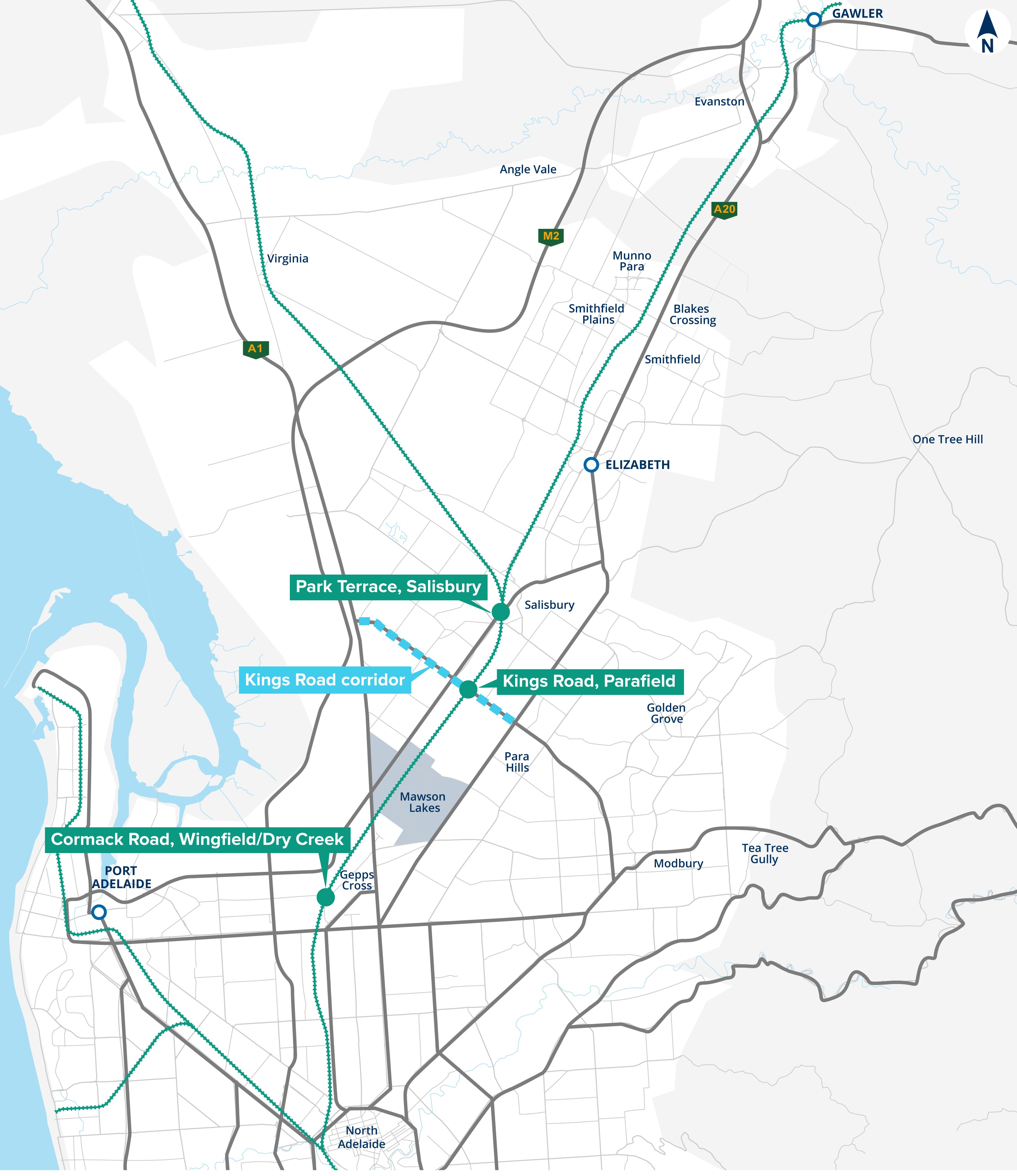
We identified the level crossings at Cormack Road in Wingfield, Kings Road in Parafield and Park Terrace in Salisbury as priority locations for planning studies.
Level crossings can lead to safety problems and travel time unpredictability as trains, cars, buses, trucks, cyclists and pedestrians’ cross paths.
The planning studies will seek to better understand the problems at each location and identify potential opportunities to remove the level crossings, improve safety and make travel easier for all users.
Kings Road Corridor Study
In addition to the level crossing at Kings Road, we are also undertaking a planning study on the Kings Road corridor (between Port Wakefield Road and Main North Road). Funded by the South Australian Government, the corridor planning study will seek to identify potential opportunities to improve Kings Road to support development growth in the surrounding area.
Level Crossing Removal Planning Program locations including Kings Road Corridor Study
Community engagement
Community and stakeholder engagement is vital to the successful identification of opportunities at each location. Local input will be used to help us better understand your experiences using these areas and what’s most important to you. Thank you to all members of the community who took the time to provide feedback during our consultation period in September 2023. Your feedback will be used to help inform the planning studies.
Following this consultation, we have prepared a what we heard summary of feedback received throughout the consultation process for each location, these summaries can be viewed below:
After initial planning work has been completed, funding will need to be sought from both the State and Federal governments to implement any potential opportunities identified.
FAQs
Why remove level crossings?
There are 126 at-grade level crossings of the road and rail network in Adelaide. Some of these level crossings boom-gates are closed to road users, including pedestrians, for up to 25% of peak traffic periods while a train passes.
Level crossings can lead to safety problems and travel time unpredictability as trains, cars, buses, trucks, cyclists and pedestrians’ cross paths. Pedestrian and vehicle collisions and boom-gate strike crashes can result in injuries or fatalities, as well as property damage and delays on transport networks.
Longer boom-gate closures can also create separation between the adjacent community and reduce amenity in residential areas.
These problems are expected to worsen as road traffic and the frequency of rail services increase with population growth in South Australia.
What are the benefits of removing level crossing?
Benefits vary across each location however, often include:
- improved safety for all users by removing the danger of trains sharing a crossing with vehicles and other users;
- increased travel time reliability by removing uncertainty around when and how long boom-gate closures will occur;
- reduced delays caused by boom-gate closures;
- improved cyclist and pedestrian connectivity and safety along the rail line and to railway stations;
- improved the efficiency and reliability of transport movements to enhance the economic productivity; and
- opportunities to add value for the community and commuters, such as creating new open space, building new shared use walking and cycling paths or commissioning public artwork.
How are level crossings prioritised for removal?
A review of Metropolitan Adelaide’s remaining at-grade level crossings has been undertaken, resulting in identification of priority sites for removal.
The criteria used to determine the highest priorities were:
- safety outcomes;
- efficiency and growth;
- community liveability;
- strategic importance;
- affordability;
- social impact;
- environmental and heritage impact;
- constructability;
- freight, peak hour and public transport hierarchy; and
- cycling and pedestrian hierarchy.
Why is Park Terrace, Salisbury considered a priority site?
Both the Gawler passenger line and the ARTC national freight line cross Park Terrace at Salisbury. The level crossing experiences significant pedestrian activity both across the rail line, and along it between the Salisbury and Nurlutta stations. Pedestrian safety incidents are high.
The high pedestrian volumes, safety concerns, and proximity to the Salisbury Town Centre results in the Park Terrace, Salisbury level crossing being a high priority for review.
Why is Kings Road, Parafield considered a priority site?
Both the Gawler passenger line and the ARTC national freight line crosses Kings Road at Parafield. The Parafield station and Park ‘n’ Ride is located just to the south of the crossing. The area around the level crossing is subject to local flooding.
The strategic importance of Kings Road, proximity to the Parafield station and Park ‘n’ Ride, and relative ease of constructability results in the Kings Road, Parafield level crossing being a high priority for review.
Why is Cormack Road, Wingfield considered a priority site?
Both the Gawler passenger line and the ARTC national freight line crosses Cormack Road at Wingfield. Cormack Road is a strategic connection to the Wingfield industrial precinct and caters for high volumes of freight and commercial vehicles.
The strategic importance of the level crossing to industrial and economic activity and the current unreliability of travel times results in the Cormack Road, Wingfield level crossing being a high priority for review.
How are level crossings removed?
When removing level crossings where rail intersect with the road network, there are generally five different options, including under or over of road or rail, or the closure of the road at the railway line. The best option will differ from site to site and not all options will be viable at all sites.
Deciding which is the best option is a major part of the planning process and a balanced decision will be made based on a detailed analysis of technical limitations and constraints, community input, an assessment of the benefits versus financial costs, likely construction impacts, environmental and heritage impacts, acquisition impacts, and the likely impact on local residents and businesses.
What will happen at the end of the planning study?
At the conclusion of this phase of the planning study a “what we heard” document will be released to the community with an overview of the feedback and insights received.
After initial planning work has been completed, the findings of the planning studies will help inform and guide Government decision-making on the funding and delivery of future level crossing removal projects.
Further Information
If you have any further enquiries, please:
- subscribe to project updates
- call 1300 794 880
- email DIT.Engagement@sa.gov.au